Screening of Sewer Networks
Screening of Sewer Networks with Zoom Camera Technology
Aging water and wastewater infrastructure is one of the biggest challenges municipalities face today. Maintenance backlogs are growing, and identifying weaknesses across vast underground networks is both time-consuming and expensive.
Xpipe introduces a smarter way forward.
Using advanced scanning and digital mapping technology, entire sewer networks can be efficiently surveyed, visualized, and analyzed—making the invisible infrastructure beneath our cities finally visible.
Making Underground Infrastructure Visible
Traditional inspection methods only reveal small sections of the network at a time. Xpipe’s scanning solution allows municipalities and infrastructure owners to digitally map entire pipe networks and manholes, presenting the results in a Street View–style interface.
Instead of guessing what lies beneath the surface, decision-makers gain instant access to visual, location-based data that shows real conditions—clearly and objectively.

A Powerful Supplement to Traditional Pipe Inspection
This technology does not replace conventional CCTV pipe inspection—it enhances it.
By scanning straight pipe sections rapidly, Xpipe helps filter out areas that are in good condition, allowing inspection teams to focus only on problematic sections that truly need attention.
Key advantages:
Scan up to 3,000–5,000 meters per day
Up to 20x faster than traditional pipe inspection
No pre-cleaning or flushing required
Immediate digital upload of inspection data
Visual Results, Real-Time Access
The scanning process is simple and efficient:
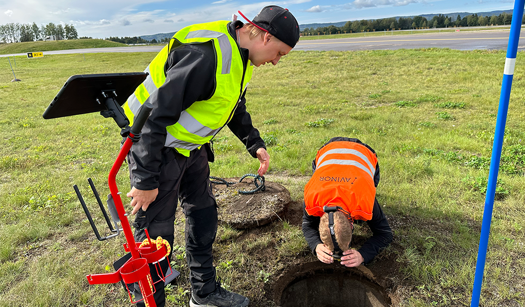
Equipment is deployed directly from the inspection vehicle
The camera is lowered into the manhole
The system scans in all directions and up to 300 meters in straight sections
Data is instantly uploaded to the Underground City (UC) application
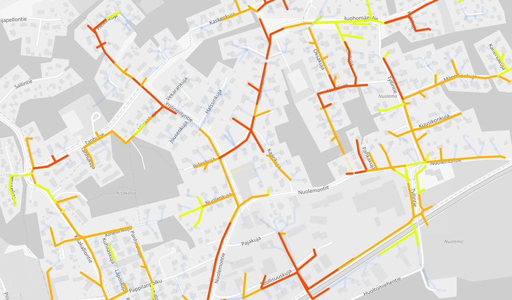
Results are displayed as a color-coded digital map:
🟢 Green – Good condition
🟡 Yellow – Medium condition
🔴 Red – Immediate attention required
Each section includes video documentation, condition grading, and recommended actions.
Smarter Decision-Making for Municipalities
Instead of spending time and budget inspecting pipes that are already in good condition, municipalities can:
Prioritize critical areas
Reduce unnecessary inspections
Plan maintenance based on real data
Improve long-term asset management
All information is securely stored in the cloud and accessible within minutes—supporting daily operations, planning, and strategic decision-making.

Integrated Digital Infrastructure Management
The UC application allows seamless integration of:
GIS data (pipes, manholes, pump stations)
Construction details
Historical maintenance records
Field updates via mobile devices
This creates a complete digital overview of the entire network and improves collaboration between municipalities, contractors, and infrastructure owners.
A Win–Win Investment
While advanced scanning is an investment, the return is clear:
Reduced operational costs
Faster inspections
Fewer unnecessary interventions
Better use of maintenance budgets
By mapping up to 20% of a sewer network annually, entire municipal systems can be fully documented within just a few years.
Ready to transform how you manage underground infrastructure?
Contact Xpipe today to discover how smart scanning and digital mapping can save time, reduce costs, and bring clarity to your water and wastewater networks.